Vegetation Management |
|||||||||||||
History |
|||||||||||||
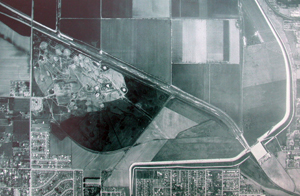
The oldest available aerial photos (taken in 1953) show that agriculture was already established in the area. Therefore it is difficult to etermine what types of natural communities existed in the area before disturbance. If the present flood control basin was originally located in close proximity to the Los Angeles River, there would have been the potential for periodic flooding which may have provided seasonal wetland habitat for migratory waterfowl and shorebirds. The L.A. River has been channelized since the 1940’s, and with the urban development of the formerly rural San Fernando Valley and adjacent watershed, intensity of rainwater flowing into the Basin has likely increased since its previously natural state. |
||
Flood plain vegetation may have been present before development, consisting of trees and shrubs that tolerate periodic inundation, yet have deep enough root system to survive through the hot summer. The wettest areas would have supported freshwater marsh, with dominant species of cattail (Typha spp.), bulrush (Scirpus), spike-rush (Eleocharis), willow water-weed (Ludwigia peploides), and water smartweed (Polygonum lapathifolium). Areas along the river and side channels probably had riparian woodland, with dominant tree species of California sycamore (Platanus racemosa), and coast live oak (Quercus agrifolia). California walnut trees (Juglans californica) and elderberry (Sambucus mexicana) were probably growing in scattered locations. It also possible that Fremont cottonwood (Populus fremontii), valley oak (Quercus lobata), and box elder (Acer negundo) were also likely present as well. Associated understory would have consisted of mulefat (Baccharis salicifolia) and coyote bush (Baccharis pilularis), several species of willow (Salix spp.) and possibly California grape (Vitis californica). Other natives include western ragweed (Ambrosia psilostachya), mugwort (Artemisia douglasiana), heliotrope (Heliotropium curvassavicum), bush monkeyflower (Mimulus aurantiacus), alkali-mallow (Malvella hederacea), and pinnate-leaved verbena (Verbena lasiostachys). |
||
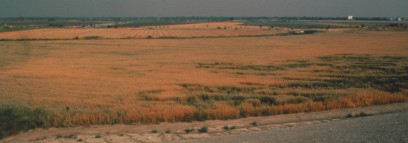
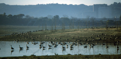
Until the late 1970’s the only native vegetation was present in river or creek channels, as the Basin was primarily agricultural fields. Native species included California walnut, willows, mulefat, coyote bush, cattail, bulrush, water smartweed and water smartweed. However, in the fall and winter the fallow agricultural fields attracted large flocks of Canada and other geese. |
||
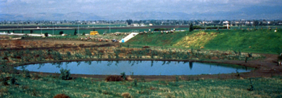
In 1988, the North Reserve was created. The area was graded and the wildlife lake was excavated, an irrigation system was installed, and planting was done. At first the City was mowing the landscape, attempting to keep the “view” of the wildlife lake visible from the main trails. The Wildlife Steering Committee was developed soon after the North Reserve was developed, and its advice convinced the City that a reserve should not be mowed, but in fact, the plants should be left to grow and that brush piles were good (not eyesores) as they provided habitat for the critters that we hoped to attract. |
||
The wildlife lake was not filled with water until the fall of 1989. Even then it wasn’t filled all the way up – only enough to keep animals from crossing over to the lake, and only during winter and spring (it was drained in summer). The Canada geese that previously wintered in the Basin on the fallow agricultural fields returned each fall, and an area on the east bank of the wildlife like was planted with annual grasses to encourage the geese. |
||
In 1991, reclaimed water was pumped into the wildlife lake at the rate of approximately 5 million gallons per day, and since 1993 the water has remained in the lake all year. During the summer the lake level is drawn down in order to provide a muddy embankment which is used by migrating shorebirds. Portions of the lake were planted with cattails and bulrushes (Scirpus californicus): blackbirds, song sparrows, yellowthroats and many other birds now utilize the shoreline vegetation for breeding and feeding. |
||
Various plantings of native vegetation have taken place in the North Reserve including cottonwood trees along Haskell Creek near the parking area (1993), additional upland plants north of the lake (part of Tillman Flood Control Project mitigation) during 1994-1995, miscellaneous willow and oak plantings between the west edge of the lake and trail (1992-1995), and the Hummingbird Hill project (1995-1996). The Hummingbird Hill project consisted of removing non-native vegetation from the north side of the Burbank Blvd. berm and planting native plants associated with California walnut and oak woodland plant communities, as well as a demonstration native landscape garden (west of the tunnel) showcasing perennials which provide food for hummingbirds (that were not present in the Reserve at that time). At the time Hummingbird Hill was one of the only native plant landscape demonstration projects in the City; over the years the battle to keep mulefat off the hill was abandoned and the area currently is not a great example of using natives for landscape, but it is the only location of Davidson’s bush mallow (Malacothamnus davidsonii) in the Basin (and one of only two sites in the San Fernando Valley). |
||
In 1995, a conceptual master plan for the Sepulveda Basin Wildlife Area was developed that resulted in an expansion of the Wildlife Area to include the area to the west of Haskell Creek and the area west of Woodley under the model airplane flight area. New trails were installed along with bridges crossing over Haskell Creek in the three places (two in the north reserve and one in the south reserve). Parking areas were expanded to the north of the reserve, and amphitheatre was created with many large boulders and a sitting area, and restrooms and a storage area were built. The original wood “viewing blinds” were replaced with concrete benches that could be utilized to set up equipment for the San Fernando Valley Audubon Society’s school children education program. Haskell Creek itself was widened in the north reserve and willow trees were planted along the Creek. Valley and coast live oak trees were planted in the “middle” area (between Haskell Creek and Woodley Ave) and a perimeter trail was built. New signage was installed. This project was completed in 1999. |
||

